

 Back
A practical guide to RTK corrections, local reference stations, and using GEODNET without deploying your own base station.
Imagine arriving at a survey site, preparing a drone mapping mission, or setting up a tractor for precise field guidance. You need positioning accurate to centimeters—not just meters. Traditionally, that might have meant installing a reference station on site. Today, a correction network can often provide an alternative.
What is an RTK base station?
An RTK base station is a GNSS receiver at a stable, known location. It observes signals from navigation satellites and provides reference data used to correct positioning errors. A second receiver—the rover—combines corrections with its own satellite observations to calculate a more precise position.
Real-Time Kinematic (RTK) positioning can deliver centimeter-level precision under suitable conditions. It is used in surveying, mapping, agriculture, construction, drones, and autonomous systems.
How does a local RTK base station work?
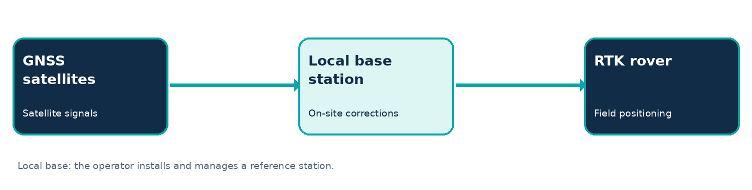
A traditional setup uses a base receiver and a rover. The operator sets up the base, establishes suitable coordinates, and sends corrections to the rover over radio or an internet connection. This provides control over the local setup but adds equipment, setup time, and maintenance.
What is Network RTK?
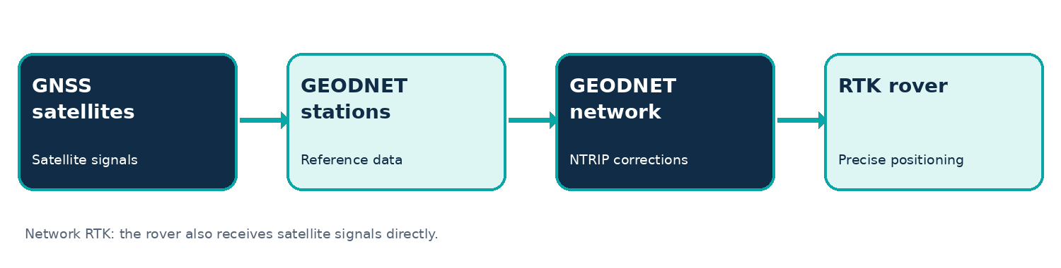
Network RTK uses existing reference stations instead of requiring each user to deploy their own. Stations continuously collect satellite observations. The network processes those observations and delivers correction streams to compatible rovers, often over the internet using NTRIP.
A rover must still receive satellite signals directly. Network corrections improve the rover’s positioning calculation; they do not replace satellite reception.
Explore the GEODNET RTK Network Explore the GEODNET RTK Network
Local base station vs. Network RTK
- Equipment — A local setup needs a reference receiver, antenna, power, and a correction link. Network RTK typically needs a compatible rover, internet connectivity, and access to a correction service.
- Setup — A local base requires installation and correct coordinates. Network RTK can reduce field setup after the rover and service are configured.
- Coverage — A local base works within the range and conditions of its communication system. Network RTK works where suitable network coverage and connectivity are available.
- Connectivity — A radio-linked local base may work without cellular internet. Network RTK generally needs an internet connection for real-time corrections.
- Responsibility — Local base owners maintain their equipment. With Network RTK, the service provider maintains the reference infrastructure while the user manages the rover and connection.
When does owning a base station make sense?
A local base can be useful for remote sites without reliable internet, permanent facilities, specialized coordinate or research requirements, and projects where the operator needs direct control of reference observations or correction delivery.
It is not automatically more accurate than Network RTK. The outcome depends on reference geometry, setup, equipment, satellite conditions, and the quality of the corrections.
When is Network RTK a better fit?
- Surveying and mapping — Teams moving between job sites can avoid setting up a separate base at each location.
- Drone mapping — RTK-capable drones can receive network corrections for positioning and georeferencing, although mapping accuracy also depends on control, calibration, and processing.
- Precision agriculture — Guidance systems can use repeatable positioning across fields with suitable coverage.
- Construction — Teams can use network corrections for site measurements and layout workflows.
- Robotics and autonomous systems — Network RTK can contribute precise global positioning alongside cameras, inertial sensors, and other navigation systems.
How GEODNET makes Network RTK accessible
GEODNET is a decentralized network of GNSS reference stations. Independently operated stations contribute satellite observations, and the network makes correction services available to compatible RTK devices. GEODNET supports NTRIP delivery and RTCM correction formats.
Under suitable conditions, compatible receivers may achieve approximately 1–2 cm RTK positioning precision. Results vary with satellite visibility, receiver quality, correction availability, multipath, and field conditions.
Check GEODNET Network Coverage
What do you need to get started?
1. A compatible RTK GNSS receiver capable of accepting the correction format.
2. Internet access through the receiver, controller, or connected phone.
3. An active correction subscription and the credentials needed to connect through NTRIP.
Explore GEODNET RTK Subscription Plans
GEO-MEASURE: a handheld option
GEO-MEASURE is a handheld GNSS RTK rover for positioning and mapping applications. It connects with a compatible mobile device and can use GEODNET network corrections. A GEO-MEASURE package includes one year of GEODNET RTK service; check the current product listing for package details and terms.
Explore GEO-MEASURE and the Carbon Fiber Survey Pole Bundle
What should you verify before choosing Network RTK?
Check network coverage, reliable internet access, receiver compatibility, correction formats, coordinate reference systems, and your project’s accuracy requirements. For critical work, verify positions against known control and follow the standards appropriate to the application.
Frequently asked questions
Precision without deploying your own base
A local RTK base station remains valuable for some projects, but it is no longer the only way to access high-precision positioning. Where coverage and connectivity are suitable, GEODNET lets compatible devices receive corrections from a distributed reference network—so users can focus on their work rather than managing a separate station.